Lipulekh: Nepali Outcry and the Truth

 Amir Singh
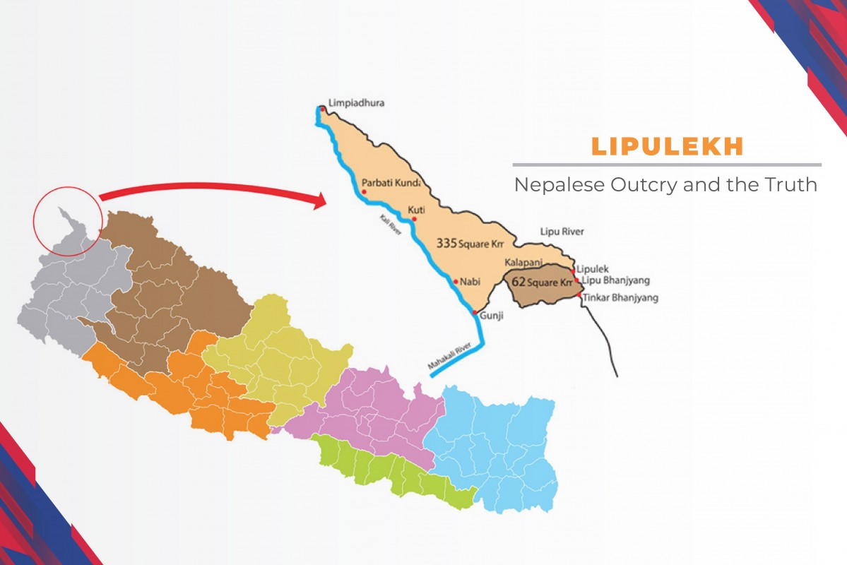
Recently, the spokesperson of the Government of Nepal and also the Minister of Finance and Communication, Dr Yubraj Khatiwada has confirmed about the approval of the map of Nepal including Limpiyadhura by the Council of Ministers of Nepal in the meeting held on the 18th of May. The map has now been publicized. It is so far the best effort applied from the Government of Nepal to claim its almost lost land. Government of Nepal must proceed now to settle it and get the rightful land of Nepal back from Indian encroachment. For a very long period of time, Limpiyadhura, Lipulekh and Kalapani have been the causes of a painful outcry wanting to burst into tears to each and every Nepali. Nepali, known as the Brave Gurkhas around the world are forced to suppress their rage against this illogical encroachment because of the inability of their government to produce similar outcry that could resonate with their tears against the Government of India which announced the inauguration of a road link in Uttarakhand’s Pithoragarh via the Lipulekh pass on Friday the 8th of May. The furor had already begun in Nepal almost 6 months back when India published its new political map claiming the ownership of these areas as disputed areas. As a long-term cunning plot, India has successfully called these areas, Limpiyadhura, Lipulekh and Kalapani as ‘disputed area’. But sadly, the government of Nepal has not been able to resolve this dispute for such a long time. Nepal has witnessed a number of internal political movements and short-sightedness of Leaders of Nepal resulting a weak, unstable and fragile Government, Bureaucracy as well as Diplomacy. The Leaders of Major Political Parties have a strong dependency on neighbor countries for POWER. India, well aware of these traits of Nepali Leaders, bureaucrats and diplomats, has been playing very well to satisfy their desire of imperialism. Limpiyadhura, Lipulekh and Kalapani are few names of Indian encroachment of Nepali lands. The news of encroachment in our borders by India is a daily news feed for us. Nepali believe that the people and the government of India will not hurt the feelings of the people of Nepal whom they consider as their true and friendly neighbor. This video cannot provide all the contents of these bitter experiences on Nepal-India border. But the major objective of this video is all about providing the historical evidence that proves these so called disputed areas, Limpiyadhura, Lipulekh and Kalapani are the inseparable parts of Nepal. Let’s begin with Sugauli Treaty-1816. The Sugauli Treaty surrendered the district of Kumaon and Garhwal to the British India which connected the British to the borders of Tibet for the first time from the west of Nepal. Likewise, British were connected to the east with Sikkim through the treaty of Titalia 1817. Article 5 of the treaty states: “The Rajah of Nepal renounces for himself, his heirs and successors, all claim to or connection with the countries lying to the west of the river Kali and engages never to have any connection with those countries or the inhabitants thereof.” This border river “Kali” is now called Mahakali in Nepal and Sarada in India. Undoubtedly, the origin of Mahakali River is Limpiyadhura. But India, since the British Raj has been manipulating this fact to create a misleading definition of the area as Disputed. Historical documents provide enough proofs about the actual origin of Mahakali River as Limpiyadhura. The fact that Limpiyadhura is the origin of the Mahakali River makes Lipulekh, Kalapani and Limpiyadhura the parts of Nepal. Here are the documents of proof about Limpiyadhura as the origin of Mahakali River. In 1903, Qing Dynasty of China published The World Atlas of China. This document mentions Limpiyadhura as the source of Kali River. And these so called “Disputed areas” are within the territory of Nepal according to this Map. In 1827, British Surveyor of India published a Map under the title of Gadhwal-Kumao. That map has also clearly mentioned that Limpiyadhura is the origin of Kali River. Kalapani is in the east of this River that clarifies that Limpiyadhura, Lipulekh and Kalapani are the parts of Nepal. In another major document, a map published in 1856 by British India’s survey Department under the title of “Nepal and countries adjoining to the south, west and east compiled in the Office of surveyor General of India”, in Note number 3 that included a handmade map by the then Prime Minister of Nepal, Jung Bahadur Rana. This document has also mentioned Limpiyadhura as the origin of Kali River. In another major article by Dr. Mangal Siddhi Manandhar and Dr. Hridayalal Koirala published in the Journal of Tribhuwan University on 2001 under the title of “Nepal-India Boundary Issue: River Kali as International Boundary” states Limpiyadhura as the origin of Kali River. In an interview published in The Rising Nepal, on the 15th November 2019, Senior journalist and expert Bhairab Risal said that National Census of 2018 B.S. (1961 AD) served the strong evidence that Kalapani area is Nepal’s sovereign territory. He says “I myself was deployed for the national census in that area at that time,”, adding that there was no presence of Indian paramilitary forces then and Nepali census team had conducted the survey without any problems. Presenting another evidence, “the then British governor had, in a letter, asked the people of the Kalapani region to pay land tax to Nepal government, stating that territory belonged to Nepal as per the Sugauli Treaty”, he said. According to Risal, India has cast an evil eye on Kalapani area, because of its prominent geographic structure which can be strategically important to them in monitoring the Chinese Troops Movement. The Indian military forces had set up their camp here after being chased by the Chinese Troops. However, Nepali government did not take any initiative to remove the Indian forces and get back the land despite knowing the fact that it is an inalienable part of Nepal. “The inclusion of Kalapani area in its newly published map demonstrates India’s tendency to dominate and bully a small country like Nepal,” added Risal. India since the British Raj has been creating this mayhem by manipulating the names of many places of the river. The British conspiracy began to encroach Lipulek pass by means of cartographic manipulation partly, because of less technical knowledge on Nepal’s side and largely due to less frequent visits to that area due to remoteness. Lipulek pass did not hold much attraction to Nepali rulers because of Hilsa and Tinker pass being easier routes compared to the former. All these evidences justifies that Limpiyadhura, Lipulekh and Kalapani are the parts of Nepal not disputed areas as India claims. India must realize the fact that instability and turmoil in its neighboring nations cannot bring the desired peace and development in India. It cannot have the similar approach as East India Company for they were only the imperialists and the time was not as it is now. In the description please find out the sources of information used in the making of this video. I personally would like to thank all for providing these insightful writings in an honest pursuit of awareness. In the description you can also find a link where India is opposing to CPEC [China Pakistan Economic Corridor] on a shaky ground. Editing Assistance: Rupa Karki Information Base: India’s Cartographic Manipulation of Nepali Territory A Case Of Limpiyadhura To Lipulek By Dr. Jagat K. Bhusal, A professional hydrologist and ex-chairman of ETFC Diplomatic Offensive A Must To Solve Kalapani Issue By CK Khanal लिपुलेक नेपालको भूमि हो भन्ने प्रमाण म जिउदै छु, मैले जनगणना गरेको हुँ - Bhairab Risal (Lipulekh is Nepali land, I have conducted the census, I am still alive-Bhairab Risal) https://www.youtube.com/watch?v=cNr5_fovRsU THE REAL BORDER OF NEPAL |KALAPANI-LIPULEKH BORDER ISSUE| NEPAL-INDIA BORDER | https://www.youtube.com/watch?v=-otMzY25aT4 Historic Map - 1903 National Atlas - Rand, McNally & Co.'s China. Chinese Empire… https://www.amazon.com/Historic-Map-National-McNally-Historical/dp/B07P97X6SD?th=1 New road rouses territorial dispute between India and Nepal https://www.dw.com/en/new-road-rouses-territorial-dispute-between-india-and-nepal/a-53383342 India’s opposition to CPEC on shaky ground Neither of New Delhi's two main justifications for opposing the China-Pakistan Economic Corridor stands up to scrutiny https://asiatimes.com/2020/04/indias-opposition-to-cpec-on-shaky-ground/ यस्तो छ सरकारले पारित गरेको नेपालको नयाँ नक्सा https://www.onlinekhabar.com/2020/05/865448